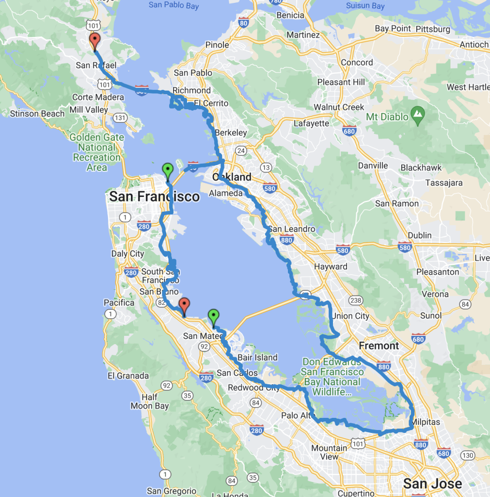
In November of 2021 we decided to take advantage of a lull in the pandemic and celebrate our 20th Anniversary with a tour around the San Francisco Bay. The Bay Trail is still under construction, so we started planning our route using the official maps found here.

To fill in the missing gaps we used Google Street View and other sources to find the safest connections. There are also many alternate route choices. Our selections were somewhat arbitrary and many times we only chose a particular route because we had already ridden the other routes on previous day trips.

Our GPS tracks can be seen here and show the route we chose. Here are some notes about the tracks:
- We wanted to shorten the first day so that we could reach relatives in the south bay in a single day, so we used the Larkspur ferry to San Francisco. The bike route from Larkspur to the SF ferry terminal is well documented, but we’ve ridden it many times before. So these tracks begin at the SF ferry building.
- We chose to take a more inland route through Bay View and Hunters Point. The trail has not been completed there yet, and we wanted to avoid some questionable neighborhoods.
- Around SFO is not attractive, but there is a full bike lane along the roads leading to and from the airport.
- The gap in the tracks in Burlingame is where we left the trail to stay overnight with family.
- At the southeastern most tip, on the Coyote Creek Trail, we had to cross under 237 by finding a break in the fencing and walk along a closed section of trail. We were not the only ones using this connection.
- Around Fremont were many miles of highway, but in every case we were either on a well marked bike lane or the sidewalks were designated as bikeable.
- Alameda Island is a great place to bicycle. We only bypassed it this time because we’ve ridden it several times in the past and wanted to see the more direct route from OAK to Jack London Square.
This tour was also the first with our new Bike Friday New World Tourist bikes, since our Tandem broke down the previous March. Here is a video of the tour, which includes a memorial to our tandem.
One of the most unexpected experiences of the tour was how much bicycle infrastructure is already in place along the route. When we got back home we put together some unscientific stats about what we saw:
66%, 110 miles of the route was on separated class I bike paths. It is the ultimate goal for the entire route to be at this level, but we thought this was a great start. Two thirds of the paths were paved. Some were rough or in poor condition but still ok for our touring tires.
For 18%, 30 miles we were on roads with bicycle support. Most of these were typical bike lanes painted at the side of the road, and several had an additional gap drawn, further separating us from traffic. We only saw 2.5 miles where the bike lane was drawn unsafely, within the strike zone of parked car doors.
12%, 19 miles were on roads with no designated bike support, but they either had a shoulder or sidewalk we could ride, or were quiet residential streets with low speed limits.
Only 4%, 8.6 miles were on roads with heavy traffic where we had to take a lane. A few had chevrons drawn to alert drivers, but we were still having to share the lane. Much to our surprise, one of those roads was the one leading to our house. We tend not to notice because we are used to it and put up with the unsafe conditions.